ELBARA is set in a unique place – near natural swamp. Learn more about advantages and opportunities of this localization.
Bubnow Wetland is natural swamp in the eastern Poland, localized in Polesie National Park (PNP), mostly in Urszulin commune. In this relatively small area there is a great diversity of natural conditions and rare species of plants and animals [1] – Bubnow includes a Special Protection Area for birds. This area is also unique due to very low civilization impact. There is no irrigation or artificial water reservoirs, and mainly traditional agriculture is used near Bubnow Wetland. For this reason soil there is mostly undisturbed state and free of contaminations, so could be a good reference for research.
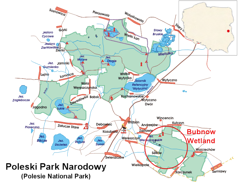
Fig 1. Map of Polesie National Park and marked Bubnow Wetland (based on http://poleskipn.pl)
Soil in Bubnow Wetland is arenosol [2] consist average 82.9% sand, 15.5% silt and 1.6% clay. The mean content of soil organic matter in Polesie is 3.2% [3]. Detailed spatial visualizations of this data are presented on Fig 2-6. The most common type of soils in this area are hydrogenic soils like peat, black earth, soil muck and glial soil. The peatlands occupy more than 41% of the park, which there are two distinct groups – the open peatbog and forest peatland
![Fig 2. Spatial distribution of sand in the 0-10 cm soil layer in the area of Urszulin commune [4]](http://elbara.pl/wp-content/uploads/2016/04/7a-sand.png)
Fig 2. Spatial distribution of sand in the 0-10 cm soil layer in the area of Urszulin commune [4]
![Fig 3. Spatial distribution of silt in the 0-10 cm soil layer in the area of Urszulin commune [4]](http://elbara.pl/wp-content/uploads/2016/04/7b-silt.png)
Fig 3. Spatial distribution of silt in the 0-10 cm soil layer in the area of Urszulin commune [4]
![Fig 4. Spatial distribution of clay in the 0-10 cm soil layer in the area of Urszulin commune [4]](http://elbara.pl/wp-content/uploads/2016/04/7c-clay.png)
Fig 4. Spatial distribution of clay in the 0-10 cm soil layer in the area of Urszulin commune [4]
![Fig 5. Spatial distribution of soil bulk density in the 0-10 cm soil layer in the area of Urszulin commune [4]](http://elbara.pl/wp-content/uploads/2016/04/8a-BD.png)
Fig 5. Spatial distribution of soil bulk density in the 0-10 cm soil layer in the area of Urszulin commune [4]
![Fig 6. Spatial distribution of organic material (OM) in the 0-10 cm soil layer in the area of Urszulin commune [6]](http://elbara.pl/wp-content/uploads/2016/04/43a-OM.png)
Fig 6. Spatial distribution of organic material (OM) in the 0-10 cm soil layer in the area of Urszulin commune [6]
In PNP region is warm temperate climate (the so-called “Land of the Great Valleys climate”), with continental features – short spring and autumn (less than 50 days), and long summer and winter (more than 110 days).

Fig 6. Typical annual temperature and precipitation distribution in PNP (based on http://poleskipn.pl)
Bedrock of PNP are quaternary or neogen sediments, deposited in cretaceous rocks. The flat countryside caused by the presence of glaciers (variation in absolute altitudes – less than 20 m [3]) and geology of PNP determine the appearance of shallow ground water, ponds, peat pits and the occurrence of a large swamps [4].
![Fig 7. Geological map of Polesie National Park [5]](http://elbara.pl/wp-content/uploads/2016/04/geology1.jpg)
Fig 7. Geological map of Polesie National Park [5]

Fig 8. Section line (black dashed line from Fig 7), numer represent:
Quaternary, Holocene: 1 – peats and peaty muds. Pleistocene, Vistulian: 2 – lacustrine-flood silts, 3 – lacustrine-flood sands. Wartanian: 4 – fluvial-periglacial sands and silts. Odranian: 5 – esker sands and silts, 6 – sands, gravels and boulders of end moraines, 7 – glacial sands and gravels, 8 – tills, 9 –glaciofluvial sands and gravels. Holstein interglacial:10 – lacustrine sands and silts, 11 – glaciofluvial sands, 12 – tills, Prepleistocene: 13 – clay and deluvial sands. Tertiary, Neogene: 14 – quartz sandstone, 15 – glauconitic sands, 16 – clays with ferriferous concretion. Cretaceous, Maastrichtian: 17 – marls, 18 – chalk, 19 – the rocks.
There is a various vegetation in this region The largest area (30.1%) is covered with continental mixed forest (Querco roboris-Pinetum), 23.2% swamp birch forest (Betuletum pubescentis) and 14.6% alder carr (Ribo nigri-Alnetum) [7]. Leaf Area Index (LAI) and fraction of vegetation cover (fCover) were measured in four different places, including Bubnow Wetland (Fig 5.). Results are shown in table 1 and 2.
![Fig 5. Localization of LAI and fCover measurements [6]](http://elbara.pl/wp-content/uploads/2016/04/veg.jpg)
Fig 9. Localization of LAI and fCover measurements [6]
Table 1. Leaf Area Index statistics [8]
| Bubnow Wetland |
Dominiczyn Forest |
Krowie Bagno meadow |
Wereszczyn cultivated fields |
|
| Mean | 2,53 | 4,56 | 2,98 | 1,35 |
| Median | 2,52 | 4,56 | 3,35 | 1,36 |
| Stand. deviation | 0,31 | 0,09 | 0,84 | 0,53 |
| Skewness | -0,05 | 0,76 | -0,92 | 0,33 |
| Kurtosis | -1,03 | 1,42 | -0,66 | -0,54 |
Table 2. fCover statistics [8]
| Bubnow Wetland |
Dominiczyn Forest |
Krowie Bagno meadow |
Wereszczyn cultivated fields |
|
| Mean | 0,57 | 0,59 | 0,73 | 0,35 |
| Median | 0,58 | 0,58 | 0,83 | 0,36 |
| Stand. deviation | 0,06 | 0,03 | 0,19 | 0,15 |
| Skewness | 0,03 | 0,93 | -1,23 | 0,15 |
| Kurtosis | -1,13 | 1,32 | 0,00 | -1,06 |
Agrophysics Institute of PAS has a three agro-meteorological stations in this region: mainly in Bubnow, Sęków and Kulczyn. Bubnow Wetland is studied by Institute since 2006. The research concern in measurements such as moisture, surface temperature, water potential and thermal properties of soil, precipitation, speed and direction of wind, pressure, temperature and humidity of air. These result are extended by SMOS satellite data and ELBARA-III radiometer set at Sęków.
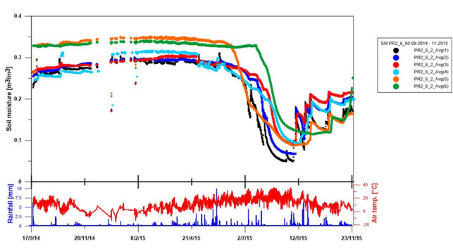
Fig 10. Annual results of soil moisture (at different depths) and weather (temperature and precipitation) from Sęków station.
![Fig 12. Central-eastern region of Poland between the rivers Bug and Vistula. Two hexagonal shapes depict areas of interest (AOI) for Podlasie and Polesie in particular SMOS DGG pixels. Rectangular windows (in blue) show selected areas of Polesie and Podlasie which were measured for soil physical properties. Area of each soil test field is comparable to the area of a single DGG SMOS pixel. The grey scale background presents SMOS data values for SM, within the scale and histogram on the inset. The foreground overlay of CORINE CLC6 classes given by shapes is for exemplification of forests (in green and yellow) and for inhabited areas (in black) in broad regional scales. [7]](http://elbara.pl/wp-content/uploads/2016/04/sm3.jpg)
Fig 11. Central-eastern region of Poland between the rivers Bug and Vistula. Two hexagonal shapes depict areas of interest (AOI) for Podlasie and Polesie in particular SMOS DGG pixels. Rectangular windows (in blue) show selected areas of Polesie and Podlasie which were measured for soil physical properties. Area of each soil test field is comparable to the area of a single DGG SMOS pixel. The grey scale background presents SMOS data values for SM, within the scale and histogram on the inset. The foreground overlay of CORINE CLC6 classes given by shapes is for exemplification of forests (in green and yellow) and for inhabited areas (in black) in broad regional scales. [7]
![Fig 11. Example water content results (measured by TDR’s) marked on area of Urszulin commune [5]](http://elbara.pl/wp-content/uploads/2016/04/8c-WC-TDR.jpg)
Fig 12. Example water content results (measured by TDR’s) marked on area of Urszulin commune [5]
51°21’19.1″ (51.355315) N
23°16’06.5″ (23.268475) E
[1] Demetraki-Paleolog A., Planktonic rotifer communities of different types of peat-bog reservoirs and wetlands of Poleski National Park (eastern Poland), Teka Komisji Ochrony i Kształtowania Środowiska Przyrodniczego, 2010 (http://www.pan-ol.lublin.pl/wydawnictwa/TOchr7/Demetraki.pdf),
[2] Niewiadomski A., Tołoczko W., Characterisitics of soil cover in Poland with special attention paid to the Łódź region, Natural environment of Poland and its protection in Łódź University Geographical Research, 2014 (http://hdl.handle.net/11089/5595)
[3] Usowicz B., Marczewski W., Usowicz J., Łukowski M. Lipiec J., Comparison of surface soil moisture from SMOS satellite and ground measurements, International Agrophysics, 28, 2014 (http://produkcja.ipan.lublin.pl/uploads/publishing/files/11_Usowicz%2028%203.pdf)
[4] Łukowski M., Usowicz B., Surface soil moisture. Satellte and ground-based measurements, Acta Agrophysica Monographiae, 2014
[5] Stanisław Radwan, Poleski Park Narodowy – monografia przyrodnicza, Morpol, 2002
[6] Usowicz B. Marczewski W, Lipiec J. Usowicz J. B., Sokołowska Z., Dąbkowska-Naskręt H. Hajnos M., Łukowski M., Woda w glebie. Pomiary naziemne i satelitarne w badaniach zmian klimatu, Wydawnictwo Naukowe FRNA, 2009
[7] Bogdanowicz R., Jokiel P., Pociask-Karteczka J., Wody w parkach narodowych Polski, Institute of Geography and Spatial Management, 2012 (http://www.geo.uj.edu.pl/publikacje,000182?&page=monografie&menu=1&lang=1)
[8] Łukowski M., Usowicz B., Analiza wegetacji LAI i fCover dla wybranych obszarów zachodniego Polesia, Acta Agrophysica, 14, 2009 (http://www.old.acta-agrophysica.org/artykuly/acta_agrophysica/ActaAgr_172_2009_14_3_629.pdf)