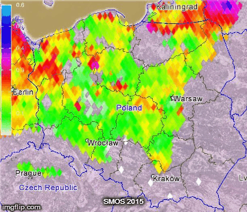
SMOS (Soil Moisture and Ocean Salinity) is ESA satellite intended to collect results of brightness temperature measurements. This data increasing our knownledge of global water cycle and its influence to climate. SMOS like ELBARA is working as a passive radiometer in L-Band (1420 MHz). With 35–50 km spatial resolution, satellite achieve global coverage every three days. Our team is engaged in SMOS data processing, especially for water content in Polish areas.
The grey spots (no data) means RFI’s or frozen soil (at winter months). White spots on summer correspond to areas threatened by drought. Legend show water content in m3/m-3 for certain day of year (DoY). DoY calendar is available on this page »